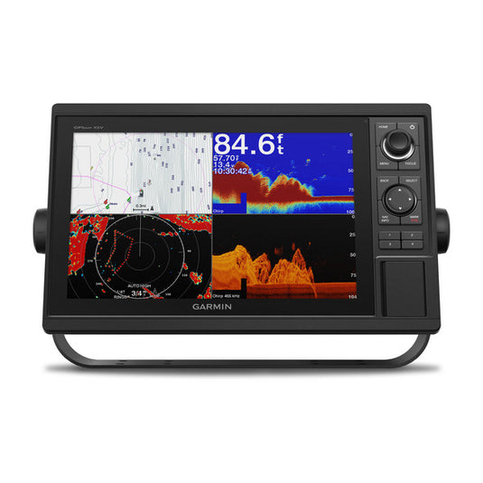
Garmin GPSMAP® 1242xsv 12-inch Chartplotter/Sonar Combo Is All-in-1 Solution with Garmin Navionics+ coastal and inland water charts for the U.S. and Canada
Model: 010-01741-50
UPC: 753759175511
- Large, bright 12" screen with keypad interface and multifunction control knob
- Supports all-seeing live sonar, which includes LiveScope™ sonar (transducers sold separately)
- Preloaded Garmin Navionics+™ coastal charts and inland mapping feature Auto Guidance+™ technology (Auto Guidance+ is for planning purposes only and does not replace safe navigation operations); plus, there’s support for optional Garmin Navionics Vision+™ premium map content.
- Built-in wireless capabilities for Garmin mobile apps
- See RPMs, fuel flow, temperature, trim and more for up to four of your compatible Mercury® engines by using the SmartCraft® Connect gateway
- Supports the Garmin Marine Network; allows sharing of sonar, radar, maps, user data, and NMEA 2000® and NMEA 0183 network connectivity support, including autopilots, digital switching, weather, media, VHF, AIS and other sensors
- Includes Quickdraw Contours map drawing software
- Built-in Garmin SailAssist™ features include laylines, race features, set and drift, wind data and more
- Integrated ANT® connectivity support for use with compatible quatix® smartwatches, the gWind™ Wireless 2 transducer, GNX™ Wind marine instrument and remote controls (sold separately)
Experience an advanced all-in-one solution with our 12" GPSMAP® 1242xsv keyed combo. It features a large, bright screen coupled with a keypad interface and multifunction control knob. It comes with built-in support for Garmin CHIRP sonar along with CHIRP ClearVü™ and CHIRP SideVü™ scanning sonars. The combo also supports Panoptix™ and LiveScope™ sonar products, including the LiveScope™ Plus System and a wide range of other transducers (sold separately). Use built-in Wi-Fi® technology to pair with the free ActiveCaptain® smatrphone app for access to the OneChart™ feature, smart notifications, Garmin Quickdraw™ Community data and more. Garmin Marine Network support allows sharing of sonar, maps, user data, radar, IP cameras and live sonar among multiple units. Plus, there’s NMEA 2000® and NMEA 0183 network connectivity support, including autopilots, digital switching, weather, media, VHF, AIS and other sensors. These units also include integrated ANT® connectivity support for use with compatible quatix® smartwatches, the gWind™ Wireless 2 transducer, GNX™ Wind marine instrument and wireless remote controls (sold separately). Preloaded Garmin Navionics+™ coastal charts and inland mapping feature Auto Guidance+™ technology (Auto Guidance+ is for planning purposes only and does not replace safe navigation operations.) Plus, there’s support for optional Garmin Navionics Vision+™ premium map content. The combo also includes Quickdraw Contours software and the Quickdraw Community on our Garmin Connect™ online network. See RPMs, fuel flow, temperature, trim and more for up to four of your compatible Mercury® engines by using the SmartCraft® Connect gateway.
Specifications
| Performance and Physical |
| Dimensions |
14.1"" x 8.9"" x 2.7"" (35.8 x 22.6 x 6.9 cm) |
| Display size |
10.3"" x 6.4"" (26.2 x 16.3 cm) |
| Display resolution |
1280 x 800 |
| Display type |
WXGA display |
| Weight |
5.2 lbs |
| Water rating |
IPX7 |
| Power consumption |
Max power usage at 10 Vdc: 34.8 W |
| Antenna |
Internal or external over NMEA 2000 |
| Mounting options |
Bail or flush |
| Receiver |
10 Hz high-sensitivity |
| Garmin Marine Network™ ports |
2 |
| Preloaded maps |
Garmin Navionics+ coastal and inland water charts for the U.S. and Canada |
| Accepts data cards |
2 SD™ cards |
| Waypoints |
5,000 |
| Routes |
100 |
| Track log |
50,000 points; 50 saved tracks |
| Tide tables |
Yes |
| Garmin Radar compatible |
Yes |
| Garmin Sonar compatible |
Yes (built-in) |
| Garmin SmartMode compatible (customizable monitor presets) |
Yes |
| Supports AIS (tracks target ships position) |
Yes |
| Supports DSC (displays position data from DSC-capable VHF radio) |
Yes |
| Garmin Meteor™ Audio System compatible |
Yes |
| Supports FUSION-Link™ compatible radios |
Yes |
| GSD™ Black Box sonar support |
Yes |
| GCV™ Black Box sonar support |
Yes |
| ActiveCaptain compatible |
Yes |
| Garmin Helm compatible |
Yes |
| GRID™ (Garmin Remote Input Device) compatible |
Yes |
| Wireless remote compatible |
Yes |
| Dual-frequency (50/200 kHz) sonar capable |
Yes |
| Dual-beam (77/200 kHz) sonar capable |
Yes |
| Transmit power |
1 kW traditional; 1 kW CHIRP |
| CHIRP sonar technology |
Yes (Built-in) |
| ClearVü |
Yes with CHIRP (built-in) |
| SideVü |
Yes with CHIRP (built-in) |
| Maximum depth |
5,000 ft at 1kW (depth capacity is dependent on water bottom type and other water conditions) |
| Bottom lock (shows return from the bottom up) |
Yes |
| Water temperature log and graph |
Yes |
| Sonar recording |
Yes |
| Sonar history rewind |
Yes |
| NMEA 2000® compatible |
Yes |
| Transducer pin numbers |
12 |
| NMEA 0183 input ports |
1 |
| NMEA 0183 output ports |
1 |
| Video input ports |
1 BNC |
| Video output ports |
None |
| Wireless connectivity |
Yes |
What's in the Box:
- GPSMAP 1242xsv chartplotter Garmin Navionics+ coastal and inland water charts for the U.S. and Canada
- Power/data cable
- NMEA 2000 T-connector
- NMEA 2000 drop cable (2 m)
- Bail mount kit with knobs
- Flush mount kit with gasket
- Protective cover
- Trim piece snap covers
- Documentation
- 8-pin transducer to 12-pin sounder adapter cable